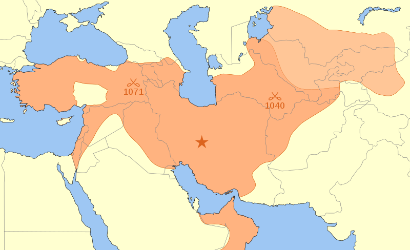
Seljuk Empire locator map.svg
조무위키

SVG 파일의 PNG 형식의 미리보기 크기: 800 × 488 픽셀. 다른 해상도: 320 × 195 픽셀 | 640 × 390 픽셀 | 1,024 × 625 픽셀 | 1,280 × 781 픽셀 | 2,560 × 1,562 픽셀
원본 파일 (SVG 파일, 실제 크기 800 × 488 픽셀, 파일 크기: 161 KB)
이 파일은 위키미디어 공용에 있으며, 다른 프로젝트에서 사용하고 있을 가능성이 있습니다. 해당 파일에 대한 설명이 아래에 나와 있습니다.
The factual accuracy of this map or the file name is disputed.
Reason: False in Anatolia according to Shepherd's map File:Europe mediterranean 1097.jpg, which represents Anatolia as entirely Seljuk except two very reduced areas around Sinop & Trebizond, but a very enlarged area around armenian Cilicia. |  |
파일 설명
| 설명Seljuk Empire locator map.svg |
English: A map showing the Great Seljuk Empire at its height, upon the death of Malik Shah I in 1092.
Nederlands: Het Seltsjoekenrijk op het toppunt van haar macht in nl:1092, ten tijde van de dood van nl:Malik Sjah I. Na diens dood viel het rijk uiteen in verschillende staatjes. |
| 날짜 | |
| 출처 | 자작 |
| 저자 | MapMaster |
References
- Black, Jeremy The Atlas of World History, Covent Garden Books, American Edition, New York, p. p. 228 , ISBN 9780756618612
- Grousset, René (1970) The Empire of the Steppes: A History of Central Asia, New Brunswick:Rutgers University Press, 8th paperback edition, 2002, p. 156.
- Hall, Simon and John Haywood (1997) The Complete Atlas of World History: The Medieval & Early Modern World, A.D. 600 - 1783, Armonk, NY: Sharpe Reference.
- Holt, Peter Malcolm; Ann K. S. Lambton; Bernard Lewis (1977) The Cambridge history of Islam, Volume 1, p, 260, ISBN 978-0521291354.
- Hourani, Albert (1991) A History of the Arab Peoples, Cambridge, Massachusetts: The Belknap Press of Harvard University Press, p. 467.
- Shepherd, William (1911) "Europe and the Mediterranean Lands about 1097", Historical Atlas, New York: Henry Holt and Company.
In general, the map was based on Shepherd and on Hall & Haywood, with modifications based on Grousset and Hourani (Hourani's map excludes the area retaken by Byzantium and the Crusaders in 1097-1100). Other maps show the Empire extending into present day Pakistan &/or that include Mecca, but I have found little evidence to support this.
라이선스
나는 아래 작품의 저작권자로서, 이 저작물을 다음과 같은 라이선스로 배포합니다:

|
GNU 자유 문서 사용 허가서 1.2판 또는 자유 소프트웨어 재단에서 발행한 이후 판의 규정에 따라 본 문서를 복제하거나 개작 및 배포할 수 있습니다. 본 문서에는 변경 불가 부분이 없으며, 앞 표지 구절과 뒷 표지 구절도 없습니다. 본 사용 허가서의 전체 내용은 GNU 자유 문서 사용 허가서 부분에 포함되어 있습니다.http://www.gnu.org/copyleft/fdl.htmlGFDLGNU Free Documentation Licensetruetrue |
- 이용자는 다음의 권리를 갖습니다:
- 공유 및 이용 – 저작물의 복제, 배포, 전시, 공연 및 공중송신
- 재창작 – 저작물의 개작, 수정, 2차적저작물 창작
- 다음과 같은 조건을 따라야 합니다:
- 저작자표시 – 적절한 저작자 표시를 제공하고, 라이센스에 대한 링크를 제공하고, 변경사항이 있는지를 표시해야 합니다. 당신은 합리적인 방식으로 표시할 수 있지만, 어떤 방식으로든 사용권 허가자가 당신 또는 당신의 사용을 지지하는 방식으로 표시할 수 없습니다.
- 동일조건변경허락 – 만약 당신이 이 저작물을 리믹스 또는 변형하거나 이 저작물을 기반으로 제작하는 경우, 당신은 당신의 기여물을 원저작물과 동일하거나 호환 가능한 라이선스에 따라 배포하여야 합니다.
이 라이선스 중에서 목적에 맞는 것을 선택하여 사용할 수 있습니다.
설명
이 파일이 나타내는 바에 대한 한 줄 설명을 추가합니다
گستردگی مرزهای ایران در دورهٔ سلجوقیان در زمان مرگ سلطان ملک شاه.
이 파일에 묘사된 항목
다음을 묘사함
10 3 2008
image/svg+xml
파일 역사
날짜/시간 링크를 클릭하면 해당 시간의 파일을 볼 수 있습니다.
| 날짜/시간 | 섬네일 | 크기 | 사용자 | 설명 | |
|---|---|---|---|---|---|
| 현재 | 2014년 6월 5일 (목) 22:24 |  | 800 × 488 (161 KB) | wikimediacommons>Ras67 | frame removed |
이 파일을 사용하는 문서
다음 문서 1개가 이 파일을 사용하고 있습니다:
메타데이터
이 파일에는 카메라나 스캐너가 파일을 만들거나 디지털화하는 데 사용하기 위해 기록한 부가 정보가 포함되어 있습니다.
프로그램에서 파일을 편집한 경우, 새로 저장한 파일에 일부 부가 정보가 빠질 수 있습니다.
| 너비 | 800 |
|---|---|
| 높이 | 488 |
